


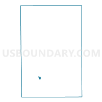
Voting District 0814282001002, Kent County, Michigan
About
Outline

Summary
| Unique Area Identifier | 597465 |
| Name | Voting District 0814282001002 |
| County | Kent County |
| State | Michigan |
| Area (square miles) | 0.41 |
| Land Area (square miles) | 0.41 |
| Water Area (square miles) | 0.00 |
| % of Land Area | 100.00 |
| % of Water Area | 0.00 |
| Latitude of the Internal Point | 42.87862790 |
| Longtitude of the Internal Point | -85.64085990 |
Maps

Graphs
Select a template below for downloading or customizing gragh for Voting District 0814282001002, Kent County, Michigan


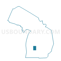
Neighbors
Neighoring Voting District (by Name) Neighboring Voting District on the Map
- Voting District 0813400003051, Kent County, MI
- Voting District 0814282001001, Kent County, MI
- Voting District 0814282001003, Kent County, MI
- Voting District 0814282001007, Kent County, MI
- Voting District 0818894001002, Kent County, MI
Top 10 Neighboring County Subdivision (by Population) Neighboring County Subdivision on the Map
- Grand Rapids city, Kent County, MI (188,040)
- Wyoming city, Kent County, MI (72,125)
- Kentwood city, Kent County, MI (48,707)
Top 10 Neighboring Place (by Population) Neighboring Place on the Map
Top 10 Neighboring Unified School District (by Population) Neighboring Unified School District on the Map
- Kentwood Public Schools, MI (61,913)
- Kelloggsville Public Schools, MI (12,317)
- Godwin Heights Public Schools, MI (11,968)
Top 10 Neighboring State Legislative District Lower Chamber (by Population) Neighboring State Legislative District Lower Chamber on the Map
- State House District 72, MI (103,319)
- State House District 77, MI (92,442)
- State House District 75, MI (86,627)
Top 10 Neighboring State Legislative District Upper Chamber (by Population) Neighboring State Legislative District Upper Chamber on the Map
Top 10 Neighboring 111th Congressional District (by Population) Neighboring 111th Congressional District on the Map
Top 10 Neighboring Census Tract (by Population) Neighboring Census Tract on the Map
- Census Tract 46, Kent County, MI (5,629)
- Census Tract 129.01, Kent County, MI (4,853)
- Census Tract 128, Kent County, MI (4,195)
- Census Tract 142, Kent County, MI (3,703)